Wednesday, June 17, 2009

Day 4.5 - The Extended SFO Visit

Did we mention we had the best time this past week? We came into today very relaxed (for us), had a lovely back road trip to the airport and even arrived with a few minutes to spare. We checked our luggage and wandered leisurely to the gate where we had time to charge the laptop, get some lunch and a cup of Peet's Coffee. Then, we spiraled into the SFO Airplane Vortex where planes do not take off and most certainly do not land.......because of weather.

At first it was a minor delay which is no big deal usually in the SFO Airplane Vortex. And we had a two hour delay getting out of Eugene and we handled that with perfect chillin' ease BEFORE we were in the zen-like trance of relaxation which we now found ourselves. No worries, we thought.

Then, we spiraled even further.....CANCELLED. "All other flights today are booked", came over the loud speaker. "If you are a famous person or buy the flight attendant a new car, we might be able to get you on the bottom of the standby list". "Did they just cancel our flight?" I asked a very relaxed Map Guy. "Yes", was his reply. So, Map Guy went to wait in a very short line for the next 45 minutes while I confirmed on-line that we had no other options but to take the 6:45 am flight TOMORROW; which as it happened United had ALREADY booked us on.

Did I mention that about 5 minutes after jumping in line and on-line, United was kind enough to call and tell me in person (okay, a computer person) that my flight had been cancelled, rebooked for o'dark thirty tomorrow morning (the reason we didn't use air miles and fly TOTALLY FREE!) and that they loved me very much. Wow, they are efficient and so thoughtful.

After an hour, Mark motioned for me to come do the business traveler thing that I used to be good at and negotiate the best solution to our problem with the United Agent who had been doing this with other people just like me (and older retired people) for the last hour. By this time, we'd figured our best option was to let them put us up in a crappy hotel, feed us and take the flight tomorrow. But, as it turns out, the cancellation was due to WEATHER which eliminates their obligation to compensate us in either of these ways. Now, if you did a check of the nationwide weather (Map Guy was all over this; watching the United big screens which were tuned to the Weather Channel), you would have noticed, that the weather looked pretty good today. So, we Pricelined a Sheraton at the Airport, managed to get our luggage back and grabbed a shuttle out of SFO for the night.

I could tell Map Guy was a brewing over the "Weather Cancellation" because when we got to the hotel he decides he's going to go work out. "You do know we've been running a bit the past couple of days, don't you?" "Yep". Okay then, let's go. So, we went and worked out. Ran our brains out for an hour. Afterwards Map Guy seemed to have accepted our circumstances. Or so I thought.

We found a Kuleto's Trattoria down the street and had a good (not free) dinner and then a nice walk back to the hotel (because we needed to walk more). I've included some pictures and (will be uploading soon) videos which I think speak for themselves about Map Guy's actual feelings about the incident. Plus, we proved without a doubt that in fact planes can take off and land at SFO.

Planes DO land at SFO!


They really do. Stay tuned for the video.........


"Airplanes Really Do Land - Take 1"

"Airplanes Really Should Land"

"Airplanes Really Can Land"


"Airplanes Really Deserve to Land"


"Spying on Map Guy"

Tuesday, June 16, 2009

Day 4 - Olema to Inverness

We had to dig deep today. Right off the bat, we had a 1350 foot climb that our legs were in no condition to conquer. Mark ran the whole thing in rock star fashion.

The terrain was a combination of everything we've seen so far. We were supposed to do 12 miles today; we did 14.7. Go figure. Mapping isn't a perfect science as I've mentioned before :>). Once again, Mark waited until we were done to tell me this. I was grateful for this.

Before I get to pictures and comments about the day, I thought I'd give some statistics that Map Guy gave me regarding our trip. You data heads will love this; I did:

Day 1 - 12.2 miles, 2:24 moving time, 3084' total elevation gain.
Day 2 -
14.0 miles, 2:41 moving time, 2750' total elevation gain, max elevation of 2557'.
Day 3 -
16.2 miles, 2:46 moving time, 1354' total eleveation gain, 3163' total descent.
Day 4 - 14.7 miles, 2:46 moving time, 2647' gain, 2750' total descent.
Day 1 -4 . . . 57.1 miles, 9835' total elevation gain, 2 sore knees (not Erin's), and 3 blisters (2 Erin's).

We started today in Olema. Our first milestone would be Mt. Whittenberg, then Reyes Hill, and then would be mostly downhill to Inverness.


This is just outside Olema at the Visitor's Center. Off we go.


From left to right:

We can see "it" (the climb) coming toward us.
Two shots of me suffering up the climb. The scenary is nice though, right?
The final push.
Here we are after the climb. He snapped my picture before I got to compose myself. I look as bad as my legs feel, whereas he looks like he's fresh as a daisy.


At this point, Map Guy says, "I'm going the additional .2 miles to the top of Mt. Whittenberg because I want to summit. You can hang here if you want." I'm thinking "Of course you do and no I'm not hanging". I say, "Sure, I'll go with you". We agree to walk it.


This was a cool shot on our way up the summit.


And then, this is the Summit. I think a little chuckle might have escaped my lips at this point. We both agreed it might not have been worth the extra effort (It wasn't, but we had to go . . . mk).


After our anti-climactic summit, we head downwards and then up some again toward Reyes Hill. Best we can figure, this meant going up again and in this case, into the fog.

The larger pic is on our way up.


The two side shots were part of some government station of sorts. We couldn't figure out what these were. It felt very "other planet like" though.


Mark on the final descent.


Us very glad about this fact (and we finally came across someone who could take a picture of both of us).


Map Guy doing his best work.


Our trip down would lead us to the town of Inverness. It is a one horse town with very friendly folks.
A picture of Inverness (I wasn't kidding).

Mark and I posing at the official sign which marks our "doneness". Of course I have to "stick the landing".

And our very favorite person of the day; Elizabeth who as a fellow hiker and runner was more than willing to give us a lift back to Olema.


What a great trip. Somehow we got it all done injury-free for which we are extremely grateful. We're glad to be done running, but we feel like super heros and are more than slightly refreshed and ready to head home and conquer the world. We are grateful to our friends and family for caring for our little people in our absense. Early reports sound like they've had a great time.

Monday, June 15, 2009

Day 3 - Mtn Home Inn to Olema Inn

Today was Day 3 and although the sun wasn't shining as brightly, it was still warm and expected to be flat to downhill running. This will be critical as tomorrow it's back to the hills.

Our route today could be divided into 3 parts:
  1. Coastal Trail (long ridge with all the grass above the coast)
  2. Forested part of Bolinas Ridge Trail
  3. Grassy part of Bolinas Ridge Trail.
This is at the start of the Coastal Trail.


Shortly thereafter, one of Mark.


Runner's World Guy (RWG) did 9 miles on Day 3. We did 16 miles which means we're either much cooler, dumber, or I need to get a new Map Guy. Today was the only day which required a cab ride to the trail head for it would have been far to long otherwise. So, how did we end up with 16 instead of 9 miles? I wasn't sure. If you know Map Guy, you know he is a man of accuracy and precision. And he totally knows his way around a GPS. That said, last night when he was finalizing our route for today like nights prior, I recall mention of something about maps having different mileage estimates and so he was never exactly sure which one would be more right. "Ok, I said. Let's just get close to RWG's mileage without going so far over like we did on Day 1 and 2". I swear he mumbled in agreement while his head bobbed up and down. But, my bad; I should have known he was up to something.

16 wasn't the number I had in mind exactly. But I am not Map Guy. After we were all done, I asked, "how far?", knowing it had to be at least 14. "16", says Map Guy. "Wow! How cool are we? Who would've thought?" And I let it go; chocking it up to the story I was fed last night.

We made it to the Olema Inn, I'd taken a long shower when the truth came out; RWG took a longer cab ride and started at the Bolinas Ridge Trail. Map Guy wanted to run the Coastal Trail but didn't want to mention this last night. Chicken! I will say this - it was a great run today. The Coastal Trail was worth the extra strain. But, keep in mind that it was relatively flat to downhill, I am post-run, showered, fed and curled up under some rad bedding as I write. And despite the line of bull I swallowed last night, I wouldn't leave home without Map Guy for about 100 reasons. After 20 years, he knows that I'm more of a "do now, deal later kind of gal" and figured he'd hedge his bets. Smart move. 16 miles! We'd planned on 42 TOTAL; not over 3 days. Feeling like a rock star!

Three shots from Forested part of Bolinas Ridge Trail.

Me going in, Mark somewhere in the middle and me coming out.


The last section was the Grassy part of the Bolinas Ridge Trail.


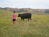
Me with a nice cow, because we just had to. Nan will say the cow is walking away because I do not smell so good. Well, he didn't either.


The Olema Inn is in sight. I think I'll sprint to the finish! NOT. But, you can't tell with a still, can you? Thank God we arrived.


Day 4 destination. Sometimes when traveling just the two of you, you must be creative when trying to both be in a picture.

Happy Trails.......